Percorsi Ciclamino - Sentiero n.836
Per l'antica via di Blessagno
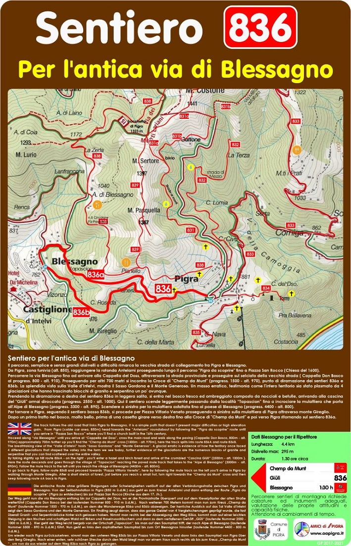
 Il percorso, semplice e senza grandi dislivelli o difficoltà rimarca la vecchia strada di collegamento tra Pigra e Blessagno.
Da Pigra, zona funivia (alt. 850), raggiungere la rotonda Antelami proseguendo lungo il percorso "Pigra da scoprire" fino a Piazza San Rocco (Chiesa del 1600).
Percorrere la via Blessagno fino ad arrivare alla Cappella del Doss, attraversare la strada provinciale e proseguire sul selciato della vecchia strada ( Cappella Don Bosco al progress. 800 - alt. 910). Proseguendo per altri 700 metri si incontra la Croce di "Chemp da Munt" (progress. 1500 - alt. 970), punto di diramazione dei sentieri 836a e 836b. La splendida vista sulla Valle d’Intelvi, mostra il Sasso Gordona e il Monte Generoso. Un masso erratico, testimonia come l'intero territorio sia stato plasmato da 4 glaciazioni che hanno trascinato blocchi di granito e serpentino un po' ovunque.
Prendendo la diramazione a destra del sentiero 6a in leggera salita, si entra nel bosco fresco ed ombreggiato composto da noccioli e betulle, arrivando alla cascina del "Giüli" ormai diroccata (progress. 2550 - alt. 1000).
Qui il sentiero scende leggermente passando dalla località “Tapascion” fino a incrociare la mulattiera che porta all'Alpe di Blessagno (progress. 3300 - alt. 890).
Scendere a sinistra per la mulattiera asfaltata fino al paese di Blessagno (progress. 4400 - alt. 800).
Per tornare a Pigra, seguendo il sentiero basso 836b, si procede per Piazza Vittorio Veneto proseguendo a sinistra sulla mulattiera di Pigra attraverso monte Gireglio.
Dopo un primo tratto nel bosco, molto bello, prima di una casetta girare verso destra fino alla Croce di "Chemp da Munt" e poi verso Pigra ritornando sul sentiero 836a.
 The track follows the old road that links Pigra to Blessagno, it is a simple path that doesn’t present major difficulties or high elevation gain.
From Pigra (cable car area, 850m) head towards the “Antelami” roundabout by following the “Pigra da scoprire” route until you arrive in “Piazza San Rocco” where you’ll find a church built in the 16th century.
Proceed along “via Blessagno” until you arrive at “Cappella del Doss”, cross the main road and walk along the paving (Cappella Don Bosco, 800m - alt. 970m) approximately 700m further up you’ll find the “Chemp da Munt” cross (1500m - alt. 970m), here the track splits into route 836A and route 836B.
The breathtaking view of the “Valle d’Intelvi” hosts “Sasso Gordona” and “Monte Generoso”. A glacial erratic is evidence of how the territory once faced 4 different glaciations that shaped the valley into the form we see today, further evidence of the glaciations are the numerous blocks of granite and serpentine that you can find
scattered over the entire valley.
By taking slightly up hill route 836A - on the right - you’ll enter a hazel and birch forest and arrive at the crumbled “Cascina Giüli” (2500m - alt. 1000m ). Here the route descends and goes through the village of “Tapascion” reaching the paved mule track that takes to the “Alpe di Blessagno” (3300m - alt. 890m). Follow the mule track to the left until you reach the village of Blessagno (4400m - alt. 800m).
To go back to Pigra, follow route 836B and proceed towards “Piazza Vittorio Veneto”, here by following the mule track on the left you’ll arrive in Pigra by walking through Monte Gireglio. After a short stretch of forest, just before you reach a small hut, turn right towards the “Chemp da Munt” cross and then keep following route
6A back to Pigra.
 Die einfache Route ohne größere Steigungen oder Schwierigkeiten verläuft auf der alten Verbindungsstraße zwischen Pigra und Blessagno. Von der Seilbahnstation in Pigra (850 m ü.d.M.) aus geht es zum Kreisel Antelami und dann entlang der Route „Pigra da scoprire“ (Pigra zu entdecken) bis zur Piazza San Rocco (Kirche aus dem 17. Jh.).
Der Weg geht nun die via Blessagno entlang bis zur Cappella del Doss, wo er die Provinzstraße überquert und auf dem Kieselpflaster der alten Straße weiterführt (Cappella Don Bosco bei der laufenden Nummer 800 - 910 m ü.d.M.). Nach weiteren 700 Metern kommt man nun zum Kreuz „Chemp da Munt“ (laufende Nummer 1500 - 970 m ü.d.M.), an dem die Wanderwege 836a und 836b abzweigen. Der herrliche Ausblick auf das Tal Valle d’Intelvi zeigt den Sasso Gordona und den Monte Generoso.
Ein Findling zeugt davon, dass das ganze Gebiet von 4 Vergletscherungen geprägt wurde, die fast überall Granit- und Serpentinblöcke hinter sich gelassen haben. Nimmt man rechts bei der Abzweigung den Weg 836a, kommt man auf einer leichten Steigung in den frischen und schattigen Wald mit Birken und Haselnusssträuchern und dann zu dem verfallenen Gehöft „Giüli“ (laufende Nummer 2550 - 1000 m ü.d.M.). Hier geht der Weg leicht bergab von der Ortschaft „Tapascion“, bis man auf den Saumpfad trifft, der nach Alpe di Blessagno (laufende Nummer 3300 - 890 m ü.d.M.) führt. Nun geht es links den asphaltierten Saumpfad bis zum Ort Blessagnos hinunter (laufende Nummer 4400 - 800 m ü.d.M.).
Um wieder nach Pigra zurückzukehren, nimmt man den unteren Weg 836b bis zur Piazza Vittorio Veneto und dann links den Saumpfad von Pigra über den Berg Gireglio. Nach einer ersten, sehr schönen Strecke durch den Wald biegt man vor einem Haus nach rechts ab bis zum Kreuz „Chemp da Munt“ , um von da aus wieder auf dem Weg 836a nach Pigra zu gelangen.
 Sentier le long de l’ancienne route de Blessagno
L’itinéraire, simple et sans grandes différences de hauteur ou de difficulté, met l’accent sur l’ancienne route reliant Pigra et Blessagno. De Pigra, zone du téléphérique (alt. 850), rejoindre le rond-point d’Antelami en continuant sur la route « Pigra da scoprire » jusqu’à la Piazza San Rocco (église de 1600). Prenez la Via Blessagno jusqu’à la chapelle Doss, traversez la route provinciale et continuez sur le trottoir de l’ancienne route. En continuant sur 700 mètres, vous arriverez à la croix de « Chemp da Munt » (progression 1500 - alt. 970), le point d’embranchement des sentiers 836a et 836b. La vue splendide sur la Vallée d’Intelvi montre le Sasso Gordona et le Monte Generoso. Un rocher erratique témoigne de la façonnement de l’ensemble du territoire de 4 glaciations qui ont entraîné des blocs de granit et de serpentine presque partout. En prenant la bifurcation à droite du chemin 836a en légère montée, vous entrez dans la jungle fraîche et ombragée de la forêt composé de noisettes et de bouleaux, arrivant à la ferme « Giüli », aujourd’hui en ruines (progress. 2550 - alt. 1000). Ici, le chemin descend légèrement, passant par le lieu-dit « Tapascion » jusqu’à ce qu’il croise le chemin muletier qui mène à l’Alpe di Blessagno (progression. 3300 - alt. 890). Descendre à gauche le long du chemin muletier goudronné jusqu’au village de Blessagno (progression 4400 - alt. 800). Pour revenir à Pigra, en suivant le sentier bas 836b, continuer jusqu’à la Piazza Vittorio Veneto en continuant à gauche sur le chemin muletier de Pigra à travers le Monte Gireglio. Après un premier tronçon dans les bois, très beau, avant une petite maison tourner à droite à la Croix de « Chemp da Munt » puis en direction de Pigra en revenant au sentier 836.
Dati Antica via di Blessagno
Lunghezza: 4.4 km
Dislivello max: 295 m
Durata: 1,30 ore circa
Percorrere sentieri di montagna richiede calzature ed indumenti adeguati, valutazione delle proprie attitudini e capacità fisiche.
Attenzione ai cambiamenti di tempo.
Vedi anche: https://www.gpsies.com/map.do?fileId=qwshpysizszwuclr
Scarica il Percorso: https://drive.google.com/file/d/1XP9Xe_ronMtysH5sOmhMEfdEMJA6hgIl/view?usp=sharing