Percorsi Ciclamino - Sentiero n.8
Circolare Piz Pasquela
Alpe di Blessagno - Zerla - Baséta - Alpe di Colonno
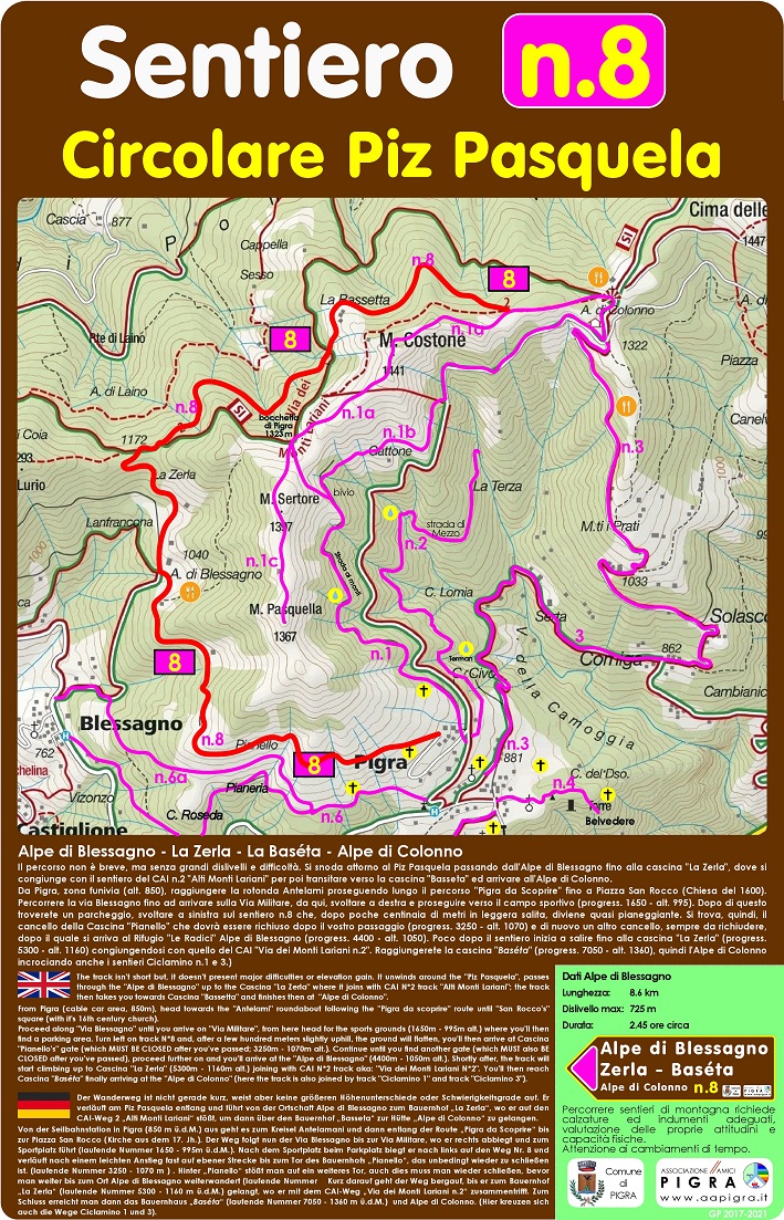
 Il percorso non è breve, ma senza grandi dislivelli e difficoltà. Si snoda attorno al Piz Pasquela passando dall'Alpe di Blessagno fino alla cascina "La Zerla", dove si congiunge con il sentiero del CAI n.2 "Alti Monti Lariani" per poi transitare verso la cascina "Basseta" ed arrivare all'Alpe di Colonno.
Da Pigra, zona funivia (alt. 850), raggiungere la rotonda Antelami proseguendo lungo il percorso "Pigra da Scoprire" fino a Piazza San Rocco (Chiesa del 1600).
Percorrere la via Blessagno fino ad arrivare sulla Via Militare, da qui, svoltare a destra e proseguire verso il campo sportivo (progress. 1650 - alt. 995). Dopo di questo troverete un parcheggio, svoltare a sinistra sul sentiero n.8 che, dopo poche centinaia di metri in leggera salita, diviene quasi pianeggiante. Si trova, quindi, il cancello della Cascina "Pianello" che dovrà essere richiuso dopo il vostro passaggio (progress. 3250 - alt. 1070) e di nuovo un altro cancello, sempre da richiudere, dopo il quale si arriva all'Alpe di Blessagno (progress. 4400 - alt. 1050). Poco dopo il sentiero inizia a salire fino alla cascina "La Zerla" (progress. 5300 - alt. 1160) congiungendosi con quello del CAI "Via dei Monti Lariani n.2". Raggiungerete la cascina "Baséta" (progress. 7050 - alt. 1360), quindi l'Alpe di Colonno incrociando anche i sentieri Ciclamino n.1 e 3.)
 he track isn't short but, it doesn't present major difficulties or elevation gain. It unwinds around the "Piz Pasquela", passes through the "Alpe di Blessagno" up to the Cascina "La Zerla" where it joins with CAI N*2 track "Alti Monti Lariani"; the track then takes you towards Cascina "Bassetta" and finishes then at "Alpe di Colonno".
From Pigra (cable car area, 850m), head towards the "Antelami" roundabout following the "Pigra da scoprire" route until "San Rocco's" square (with it's 16th century church).
Proceed along "Via Blessagno" until you arrive on "Via Militare", from here head for the sports grounds (1650m - 995m alt.) where you'll then find a parking area. Turn left on track N*8 and, after a few hundred meters slightly uphill, the ground will flatten, you'll then arrive at Cascina "Pianello's" gate (which MUST BE CLOSED after you've passed; 3250m - 1070m alt.). Continue until you find another gate (which MUST also BECLOSED after you've passed), proceed further on and you'll arrive at the "Alpe di Blessagno" (4400m - 1050m alt.). Shortly after, the track will start climbing up to Cascina "La Zerla" (5300m - 1160m alt.) joining with CAI N*2 track aka: "Via dei Monti Lariani N*2". You'll then reach Cascina "Baséta" finally arriving at the "Alpe di Colonno" (here the track is also joined by track "Ciclamino 1" and track "Ciclamino 3").
 Der Wanderweg ist nicht gerade kurz, weist aber keine größeren Höhenunterschiede oder Schwierigkeitsgrade auf. Er verläuft am Piz Pasquela entlang und führt von der Ortschaft Alpe di Blessagno zum Bauernhof „La Zerla“, wo er auf den CAI-Weg 2 „Alti Monti Lariani“ stößt, um dann über den Bauernhof „Basseta“ zur Hütte „Alpe di Colonno“ zu gelangen.
Von der Seilbahnstation in Pigra (850 m ü.d.M.) aus geht es zum Kreisel Antelamani und dann entlang der Route „Pigra da Scoprire“ bis zur Piazza San Rocco (Kirche aus dem 17. Jh.). Der Weg folgt nun der Via Blessagno bis zur Via Militare, wo er rechts abbiegt und zum Sportplatz führt (laufende Nummer 1650 - 995m ü.d.M.). Nach dem Sportplatz beim Parkplatz biegt er nach links auf den Weg Nr. 8 und verläuft nach einem leichten Anstieg fast auf ebener Strecke bis zum Tor des Bauernhofs „Pianello“, das unbedingt wieder zu schließen ist. (laufende Nummer 3250 - 1070 m ) . Hinter „Pianello“ stößt man auf ein weiteres Tor, auch dies muss man wieder schließen, bevor man weiter bis zum Ort Alpe di Blessagno weiterwandert (laufende Nummer Kurz darauf geht der Weg bergauf, bis er zum Bauernhof „La Zerla“ (laufende Nummer 5300 - 1160 m ü.d.M.) gelangt, wo er mit dem CAI-Weg „Via dei Monti Lariani n.2“ zusammentrifft. Zum Schluss erreicht man dann das Bauernhaus „Baséta“ (laufende Nummer 7050 - 1360 m ü.d.M.) und Alpe di Colonno. (Hier kreuzen sich auch die Wege Ciclamino 1 und 3).
Dati Circolare Piz Pasquela
Lunghezza: 8.6 km
Dislivello max: 725 m
Durata: 2,45 ore circa
Percorrere sentieri di montagna richiede calzature ed indumenti adeguati, valutazione delle proprie attitudini e capacità fisiche.
Attenzione ai cambiamenti di tempo.
Scarica il Percorso: https://drive.google.com/file/d/1o1lThKksZIoGo1zLOay1-MxscRzrwbKg/view?usp=sharing