Percorsi Ciclamino - Sentiero n.1
Strada ai Monti
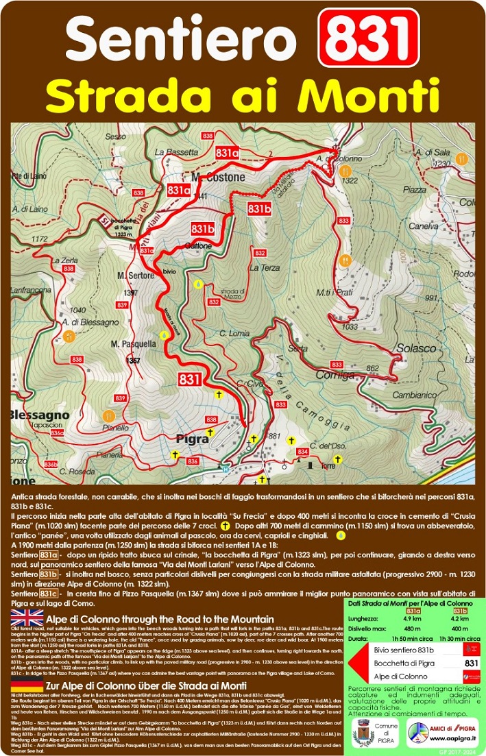
 Antica strada forestale, non carrabile, che si inoltra nei boschi di faggio trasformandosi in un sentiero che si biforcherà nei percorsi 1a, 1b e 1c.
Il percorso inizia nella parte alta dell’abitato di Pigra in località “Su Frecia” e dopo 400 metri si incontra la croce in cemento di “Crusia Piana” (m.1020 slm) facente parte del percorso delle 7 croci. Dopo altri 700 metri di cammino (m.1150 slm) si trova un abbeveratoio, l’antico “panée”, una volta utilizzato dagli animali al pascolo, ora da cervi, caprioli e cinghiali.
A 1900 metri dalla partenza (m.1250 slm) la strada si biforca nei sentieri 1A e 1B:
Sentiero 1a - dopo un ripido tratto sbuca sul crinale, “la bocchetta di Pigra” (m.1323 slm), per poi continuare, girando a destra verso nord, sul panoramico sentiero della famosa “Via dei Monti Lariani” verso l’Alpe di Colonno.
Sentiero 1b - si inoltra nel bosco, senza particolari dislivelli per congiungersi con la strada militare asfaltata (progressivo 2900 - m. 1230 slm) in direzione Alpe di Colonno (m. 1322 slm).
Sentiero 1c - In cresta fino al Pizzo Pasquella (m.1367 slm) dove si può ammirare il miglior punto panoramico con vista sull’abitato di Pigra e sul lago di Como.
 Alpe di Colonno through the Road to the Mountain
Old forest road, not suitable for vehicles, which goes into the beech woods turning into a path that will fork in the paths 1a, 1b and 1c.The route begins in the higher part of Pigra "On Frecia" and after 400 meters reaches cross of "Crusia Piana" (m.1020 asl), part of the 7 crosses path. After another 700 meters walk (m.1150 asl) there is a watering hole, the old "Panee", once used by grazing animals, now by deer, roe deer and wild boar. At 1900 meters from the start (m.1250 asl) the road forks in paths 1A and 1B.
1A- after a steep stretch "the mouthpiece of Pigra" appears on the ridge (m.1323 above sea level), and then continues, turning right towards the north, on the panoramic path of the famous "Via dei Monti Larijani" to the Alpe di Colonno.
1b - goes into the woods, with no particular climb, to link up with the paved military road (progressive in 2900 - m. 1230 above sea level) in the direction of Alpe di Colonno (m. 1322 above sea level).
1c - In ridge to the Pizzo Pasquella (m.1367 asl) where you can admire the best vantage point with panorama on the Pigra village and Lake of Como.
 Zur Alpe di Colonno über die Strada ai Monti
Nicht befahrbarer alter Forstweg, der in Buchenwälder hineinführt und dann als Pfad in die Wege 1a, 1b und 1c abzweigt.
Die Route beginnt im oberen Teil von Pigra in der Ortschaft "Su Frecia". Nach 400 Metern erreicht man das Betonkreuz "Crusia Piana" (1020 m ü.d.M.), das zum Wanderweg der 7 Kreuze gehört. Nach weiteren 700 Metern (1150 m ü.d.M.) befindet sich die alte Tränke "panée da Gus", einst von Weidetieren und heute von Rehen, Hirschen und Wildschweinen benutzt . 1990 m nach dem Ausgangspunkt (1250 m ü.d.M.) gabelt sich die Straße in die Wege 1a und 1b.
Weg 1a - Nach einer steilen Strecke mündet er auf dem Gebirgskamm "la bocchetta di Pigra" (1323 m ü.d.M.) und führt dann rechts nach Norden auf dem berühmten Panoramaweg "Via dei Monti Lariani" zur Alm Alpe di Colonno.
Weg 1b - Er geht in den Wald und führt ohne besondere Höhenunterschiede zur asphaltierten Militärstraße (laufende Nummer 2900 - 1230 m ü.d.M.) in Richtung der Alm Alpe di Colonno (1322 m ü.d.M.).
Weg 1c - Auf dem Bergkamm bis zum Gipfel Pizzo Pasquella (1367 m ü.d.M.), von dem man aus den besten Panoramablick auf den Ort Pigra und den Comer See hat.
Dati Strada ai Monti per l'Alpe di Colonno
Percorso 1a:
Lunghezza: 4.9 km
Dislivello max: 480 m
Durata: 1h 50 min circa
Percorso 1b:
Lunghezza: 4.2 km
Dislivello max: 400 m
Durata: 1h 30 min circa
N.B.:Percorrere sentieri di montagna richiede calzature ed indumenti adeguati, valutazione delle proprie attitudini e capacità fisiche.
Attenzione ai cambiamenti di tempo.
Vedi anche:
Sentiero Ciclamino n.1a: https://www.gpsies.com/map.do;jsessionid=1BBBE021057327604608B6C14039286A.fe1?fileId=fewxvtjfqwabezac
Sentiero Ciclamino n.1b: https://www.gpsies.com/map.do;jsessionid=1BBBE021057327604608B6C14039286A.fe1?fileId=dczptrtsoojpzenf
Sentiero Ciclamino n.1c: https://www.gpsies.com/map.do;jsessionid=1BBBE021057327604608B6C14039286A.fe1?fileId=ktkagyrcbeoqsdar
Scarica il percorso: https://drive.google.com/file/d/13UITMlgJo9aMqultVdoZA27-bGsqQNv0/view?usp=sharing